Siege of Pacific storms will continue to drench and blast the coastal U.S. Northwest
A siege of Pacific storms will continue to drench and blast the coastal Northwest into next week and will be joined by Ana.
The rounds of heavy rain will be enough to cause incidents of flash flooding, mudslides and travel delays from northern California to western Oregon, western Washington and southwestern British Columbia.
From this week through the middle of next week, a general 6 to 12 inches (150 to 300 millimeters) of rain can fall along the immediate coast, but locally higher amounts are possible in the eastern slopes of the coastal ranges, including the Olympic Mountains in northwestern Washington state.
Motorists and pedestrians will need to exercise caution when venturing out during the storms along secondary roads in wooded areas or steep hillsides due to the risk of falling trees and mudslides.
Large swells produced by the storms will crash ashore into next week. Seas will be too dangerous for small craft to venture out of protected waters.
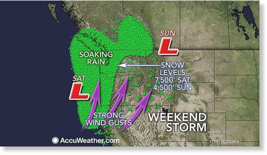
According to AccuWeather Senior Meteorologist Bernie Rayno, "After a break from the storms on Friday, the next storm in the series will hit on Saturday."
One of the storms that rolled ashore early Thursday produced wind gusts to 66 mph along the Oregon coast.
An EF-1 tornado with winds between 86 and 110 mph touched down Thursday afternoon in Longview, Washington, the National Weather Service said. It caused damage to industrial buildings, homes, trees and power lines during its 1.3-mile path.
The storm on Saturday has the potential to produce localized gusts to near hurricane force (74 mph/120 kph) along the Oregon and northern California coast, as well as the southern Cascades and northern Sierra Nevada.
Winds can be powerful enough to down tree limbs or loosely rooted trees. Any time tree limbs come down, there is the potential for sporadic power outages and blocked roads.
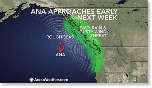
Another storm associated in part with Ana will roll ashore on Tuesday. Ana passed just to the south of Hawaii last week and is currently taking a curved path over the northern Pacific.
The center of Ana could hit anywhere from the northern coast of British Columbia to western Washington or northwestern Oregon, but the impact from heavy rain and gusty winds may be far-reaching and significant. This will be especially true after some areas are hit with a foot of rain (300 millimeters) prior to Ana's arrival.
While the rounds of rain will be less intense to the lee of the coastal ranges, enough can fall to slow travel at times along the Interstate-5 corridor from Redding, California, to Portland, Oregon, and Seattle. Rain will soak Victoria and Vancouver, British Columbia.
Strong crosswinds can create dangerous conditions for high-profile vehicles.
According to AccuWeather Western Weather Expert Ken Clark, "Snow levels will lower to around 4,500 feet on Sunday in the northern Cascades, which is down to some of the secondary passes."
Some rain and gusty winds will reach far enough south to affect the San Francisco Bay Area on Saturday, including the World Series game.
"Some rain and wind will spill into the Sacramento Valley as well on Saturday," Clark said.
The rain will reach and may benefit hard-hit drought areas of northern California and southern Oregon.
More sporadic and less intense rainfall will push farther south in California, but not to the extent to have significant impact on the long-term exceptional drought just yet.


0 reacties:
Post a Comment